PAVE 97 ΒΕ 2
Use of radio- controlled aerial photography and automated digital photogrammetry applied to archaeological excavation works, monumental surveying and aluminum-glass panel industries
PAVE 97 BE 2 is a research project funded by the General Secretariat for Research & Technology, Hellenic Ministry of Development in the frame of the Programme for Industrial Research Development.
Objectives
The research programme aims to develop a methodology for the rapid and effective surveying of archaeological sites, excavations and/or monuments in general, with the use of state-of-the-art techniques, based mainly on automated digital photogrammetry.
Background
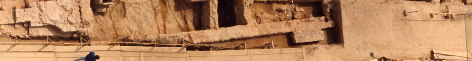
Archaeologists in Greece, need an accurate and detailed topographic plan of the site that also illustrates the archaeological finds, in order to supervise and complete the excavation works. Techniques applied by archaeologists so far to produce those kinds of plans are traditional and, very time and money consuming. A string-made grid is originally generated all over the site which is going to be surveyed. All the details of objects that fall inside a grid, are then sketched by hand or with the help of a tape-measure.
This is a trial-and-error method and the results very often do not meet the required level of accuracy. Moreover a great amount of labour effort is necessary in order to reduce the time needed for carrying out the works. This is essential, especially if we consider that at the time of the surveying, the excavation works are postponed, thus the excavation productivity is reduced dramatically.
Methodology
The introduced methodology is based on the combined use of advanced technologies, such as radio-controlled aerial photography with the help of a model helicopter, automated digital photogrammetry, image processing, three-dimensional modelling, and satellite technology (GPS) for ground control data. Through the realisation of the research project, a real-time surveying of archaeological excavations will be accomplished. Shortly after the moment of image acquisition, we will obtain the final products, i.e. digital terrain models of the excavations site, linear drawings in digital form or printed ones, rectified images etc. Those products will be in digital form and in three dimensions, therefore they could also produce photorealistic models for presentations through modelling software.
Applications
The developed methodology is also applicable to a large number of fields, where rapid surveying with topographic accuracy is required, and also where it is necessary to apply a contact-free measurement method. Such applications are all the monumental surveying, the shipbuilding and maintenance, the modelling of large building constructions like those which are going to be coated by panels of aluminium-glass.
Partnership:
GeoAnalysis S.A.
Polyline S.A.
| © 2019 Polyline Α.Ε. All Rights Reserved | Powered by Softways S.A. |